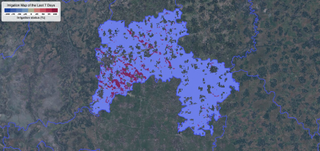
Among the several IRAS outputs that are routinely generated at fortnightly frequency during the dry season using NASA data. Over-irrigation is anticipated to have occurred in the highlighted areas in this image of a region in Bangladesh in the two weeks leading up to June 4, 2023. Over-irrigation is calculated as the difference between the estimated crop water need (based on meteorological data from GFS) and the actual water taken in by crops (estimated using Landsat data).
(Photo by Faisal Hossain, used with permission)
Using data collected by NASA satellites, a new invention is guiding farmers in Bangladesh to more efficiently irrigate their rice fields, with the hope of decreasing the country’s enormous water and energy use in the process.
In order to estimate how much water rice crops have taken in, the most recent version of the Integrated Rice Advisory System (IRAS) developed by the University of Washington and the Ministry of Agriculture in Bangladesh makes use of data from NASA’s Earth-observing Landsat satellite. Scientists can use this data to determine how much water is necessary for the crops by comparing it to weekly weather reports and recent area waterings.
Farmers then receive simple, actionable guidance via SMS once every two weeks on how to best utilise groundwater pumping for their specific area.
A civil and ecological engineering professor at the University of Washington in Seattle, Faisal Hossain, is leading the IRAS effort, and he has said that this kind of technology “can help the world become more water-efficient and energy-efficient in growing food, while also becoming more cost effective and practical for farmers.”
Almost half of Bangladesh’s workforce engages in farming as their primary occupation; this helps to sustain the country’s 170 million people. However, rice is also one of the thirstiest crops, and farmers in the country currently use 1.3 million diesel-powered watering pumps to irrigate rice fields. Of those pumps, only roughly 1,400 are solar-powered.
Similar: Wow! Maxar spacecraft captures detailed views of NASA’s Landsat 8 satellite in orbit.
Monsoon rains are no longer sufficient to replenish the depleted subsurface water due to intensive and irresponsible watering practises over the years, such as pumping more water into the field than is strictly necessary. Not only is it costly to operate diesel pumps to channel water into fields, but doing so also results in the combustion of fuels that result in the emission of carbon dioxide into the atmosphere.
Therefore, IRAS and other inventions like it would help the country save groundwater while also helping it reduce its co2 emissions, according to scientists. “To develop sustainable and climate-resilient farming for the future, we require to reduce watering waste and de-carbonize the production by utilising cost effective services that can be scaled internationally,” Hossain said in the declaration.
His organisation, which has advised 10 million farmers across Bangladesh since June, estimates that IRAS has the potential to cut water waste in farming by 30 percent and reduce carbon emissions by 300,000 tonnes annually.
Pakistan, where the technology was initially introduced in 2016, and India, where it has been in use since 2018, say scientists that the latest model has been tailored to target areas of Bangladesh known for inefficient watering procedures.
About 10,000 texts were sent out to farmers in 7 districts in northeastern Bangladesh between January and May in 2021, the annual season for the boro rice variety. According to a 2022 report, irrigation by farmers who received these messages was reduced by a factor of nine, while that by pump owners, who control the water supply to the paddy fields, was reduced by a factor of sixteen. Similarly, pump owners reported a 15% drop in income, which may be related to the decreased demand from farmers.
The paper does not specify by how much the 7 districts’ combined carbon emissions were reduced due to less watering. The innovation has been proven to have useful effects.
In 2019, a prototype of IRAS was tested on 165 farmers ahead of its official release in Bangladesh in 2021. Bulbul cyclone hit the country in November 2019, damaging almost 200,000 hectares (494,200 acres) of crop land, mostly rice fields, over the course of 3 days. The system proved very useful during this time. There has been a steady increase in the severity of these storms due to climate change, which is exacerbated by human-driven carbon emissions around the world. Bulbul was one of the longest and most damaging cyclones the country has had to contend with in over 50 years.
78% of the farmers found it useful to know how much additional water their crops needed, if any, during times of sudden rains and flash floods.
Despite the project’s progress in reaching 10 million farmers across the country, the SMS-based shipment of details includes a “non-negligible functional expense for phone texting,” which is being accommodated in the restricted funds of the Bangladeshi government. With nearly half of Bangladesh’s 170 million people still without access to a mobile network, those funds may limit the innovation’s potential.
Come speak about the latest space missions, the night sky, and more in our Space Forums. Send your feedback to community@space.com if you have any news tips, corrections, or comments.
The latest in space news, including information on upcoming rocket launches, stargazing events, and more!
Sharmila covers the scientific beat for a Seattle newspaper. Carl Sagan’s The Pale Blue Dot was where she first became interested in astronomy. She has been writing for Astronomy Magazine regularly since 2017, and she has an MA in journalism from Northeastern University.
Numerous Common

